Why Your IP Location Shows the Wrong City
For internet users and admins: understand why IP geolocation shows the wrong city, when to act, and how to request corrections.
Your IP lookup says Ashburn, Virginia. You're sitting in a kitchen in Richmond, and you haven't been anywhere near Ashburn this year. Or the pin lands on Frankfurt while you're in Munich, or on a state capital two hundred miles from your house. The first thought most people have is that something is wrong — a hijacked connection, a misconfigured router, maybe an intruder routing traffic through their line.
Take a breath. In the overwhelming majority of cases, a wrong city is not a malfunction. It's the predictable output of a system that was never designed to find you in the first place. IP geolocation is a chain of inferences — registry records, routing data, educated guesses — and each link in that chain trades precision for practicality.
Once you understand how the chain works, you can read a lookup result the way a network engineer does: you'll know which errors are normal, which ones mean something, and which two or three situations actually deserve action.
That's what this piece gives you: the full data supply chain behind that pin on the map, the real reasons it lands where it lands, and a clear framework for when a wrong location is a red flag versus background noise.
Why Your IP Address Isn't a GPS Tracker
Every packet your computer sends carries a return address, and that address belongs to your internet provider's network — not to your house, not to your laptop, not to you. An IP address is a routing label. Its entire job is to tell the internet's machinery "responses for this session go back to this network, and that network will handle the last mile." Nothing in the protocol encodes where you physically are.
GPS works on the opposite principle. Your phone listens to timing signals from multiple satellites and calculates its position by direct measurement — trilateration against atomic clocks in orbit. The result is a coordinate accurate to a few meters, produced by physics, refreshed many times per second.
IP geolocation produces its answer by paperwork. A database somewhere says "this block of addresses was registered by this company, which lists an office in this city, and our other evidence suggests these addresses are used somewhere in this region." The output is an inference layered on records, and it comes with an error radius measured in kilometers, not meters. The two technologies share the word "location" and almost nothing else.
So calibrate your expectations before you troubleshoot anything:
- Country: nearly always correct. Address blocks are registered to national jurisdictions, and that layer of the data is solid.
- State or region: usually correct, with exceptions near borders and on mobile networks.
- City: a coin flip weighted toward your ISP's infrastructure, not your street. A 20–100 km error on a residential connection is the system working as designed.
Here's the position I'd take: if a lookup tool shows a city inside your metro area, or your state's main hub city, stop investigating. That's not a bug. That's the answer the technology was built to give, and no setting on your router will sharpen it.
The Data Journey: How Your IP's Location Gets Assigned
Five organizations on Earth hand out IP addresses at the wholesale level. The global pool starts with IANA, the Internet Assigned Numbers Authority, which allocates large blocks of the address space to five Regional Internet Registries: ARIN for North America, RIPE NCC for Europe and the Middle East, APNIC for Asia-Pacific, LACNIC for Latin America, and AFRINIC for Africa. That top layer is why country-level geolocation is so reliable — the moment a block exists, it's already tagged to a continent-spanning jurisdiction.
From there, an RIR assigns smaller blocks to internet service providers, hosting companies, and large enterprises. A regional ISP might receive a /19 — that's 8,192 addresses — and register its allocation in the public WHOIS database. Here's the detail that explains half the wrong-city results on the internet: the address in that WHOIS record is the registrant's address. Typically the ISP's corporate headquarters or main network operations center. If your provider is headquartered in Denver and registers its block there, every one of those 8,192 addresses inherits "Denver" as its paper location — including the ones serving customers in Boulder and Colorado Springs.
You can see this yourself. Run your own IP through a WHOIS lookup — WhatIsMyMyIP has one — and read the OrgName, City, and State fields. Then compare that city to where you're actually sitting. The gap between those two values is the first source of error, baked in before any lookup tool touches your address.
The next link in the chain is routing. Your ISP announces its block to the rest of the internet via BGP, the Border Gateway Protocol, under its Autonomous System Number. When a lookup tool shows you "Organization: OVH SAS, ASN: AS16276," that's registry and routing data — a statement about who operates the network, not a measurement of where you are.
Finally, commercial geolocation providers — MaxMind, IP2Location, ipinfo, and others — ingest all of this public material: WHOIS records across all five RIRs, BGP announcements, and their own proprietary refinements. They package it into databases that update on a weekly or monthly cycle. When you visit an IP lookup site, the site isn't measuring anything about you. It's querying one of those third-party databases and printing whatever row it finds.
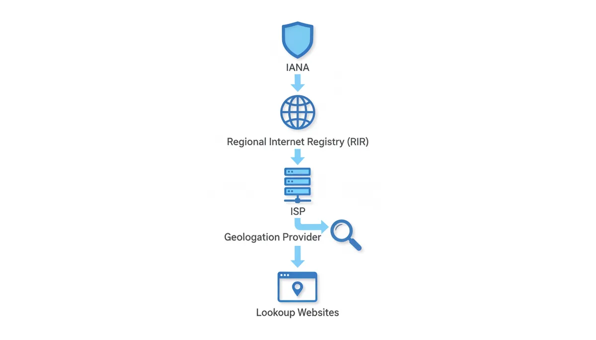
The takeaway: by the time a location reaches your screen, it's passed through at least four organizations, and every handoff favors administrative convenience over geographic precision.
The Real Culprit: Your ISP's Network Architecture
ISPs don't build an internet on-ramp in every town they serve. That would be ruinously expensive. Instead, they concentrate their equipment in a handful of facilities called Points of Presence — PoPs — and haul traffic from a wide geographic area to those few points. A PoP is where your provider's network meets the rest of the internet: racks of routers, peering links to other networks, and the DHCP servers that hand out public IP addresses.
Think of a regional mail sorting facility. Letters from forty small towns all flow to one building in the county seat, get postmarked there, and leave for the outside world from there. Nobody reads the postmark and concludes the sender lives at the sorting facility — but that's exactly the mistake IP geolocation makes, by design. Your traffic's "postmark" is the PoP.
The mechanics matter here. When your router connects, your ISP assigns it a public IP from a pool controlled by the PoP serving your region. That pool is a slice of the block the ISP registered, and geolocation databases place the pool where the network evidence points — which is the PoP's city. Your house is a detail the system never sees.
A concrete example: a regional provider serves towns across Kansas and Missouri but runs its only PoP in Kansas City. A customer in Columbia, Missouri — 250 kilometers away, in another state — gets a Kansas City IP from the Kansas City pool, and every lookup tool on the internet says Kansas City. Nothing is broken. Nothing is misconfigured. The map is showing where the traffic surfaces, not where the person sits.
Mobile carriers push this to an extreme. A national carrier may backhaul traffic from thousands of cell towers to a small number of gateway cities before it touches the public internet. That's why your phone can show a city three hours away while you're standing in your own driveway. Satellite internet does something similar — your traffic enters the terrestrial network at a ground station, and your apparent location follows the ground station, sometimes hundreds of miles off.
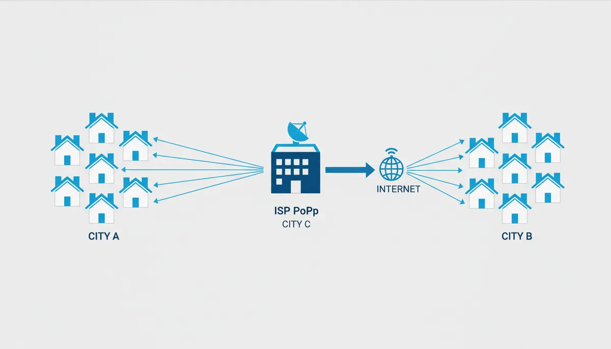
If you remember one sentence from this article, make it this one: the pin on the map marks where your traffic enters the internet, not where you are. Once you internalize that, most wrong-city results stop looking mysterious.
Inside the Black Box: How Geolocation Providers Refine the Data
Raw registry data would pin every customer of a national ISP on the same dot: headquarters. The commercial providers exist because that's not good enough, and they close the gap with methods that are genuinely clever — and fundamentally probabilistic.
The main techniques, roughly in order of weight:
- Latency triangulation. Providers maintain measurement servers in cities with known coordinates. They ping or traceroute an IP from several of these landmarks and convert round-trip times into distance estimates. Light in fiber moves at roughly 200,000 km/s, so as a rule of thumb, each millisecond of round-trip time corresponds to about 100 km of path. If an IP answers in 1 ms from Dallas and 9 ms from Chicago, it's near Dallas. Tens of thousands of these measurements carve an ISP's block into regional shards.
- Routing analysis. BGP paths and traceroute hops reveal which PoP a block's traffic flows through, anchoring it to a network facility.
- Geofeeds. A standard format (RFC 8805) lets ISPs self-publish the correct city and region for their blocks. Adoption is growing, and a well-maintained geofeed is the single most authoritative source in the whole chain.
- User-submitted corrections. Both MaxMind and IP2Location accept correction reports, which feed into validation queues.
- Commercial data partnerships. Anonymized location signals from apps and services that know a device's true position and see its IP at the same moment.
Notice what all of these have in common: none of them yields a certainty. Each produces a probability, and the providers know it. MaxMind's GeoIP2 City database ships an explicit accuracy_radius field, in kilometers, alongside every city it returns. That field is the vendor quietly telling you "the truth is somewhere in this circle."
This is also why accuracy statistics cascade the way they do. Country is a matter of registry bookkeeping, so it's nearly perfect. Region requires knowing how an ISP carves up its network, so it's strong but not bulletproof. City requires knowing which PoP serves which pool, in a network the ISP can renumber overnight — so city-level data is a best guess with a radius of tens of kilometers attached.
And when a provider has no city-level evidence for an address, some databases fall back to a default coordinate for the country. One database famously pointed its default "United States, city unknown" coordinates at a spot that happened to be a farmhouse in Kansas, and its residents spent years fielding angry visitors convinced that scammers and spammers lived there. The farm hadn't done anything. It was just the arithmetic center of a rounding decision.
Here's how the published accuracy numbers actually look, tiered by product quality. Treat these as approximate — vendors publish per-country figures that shift between releases, and the US numbers below are the strongest case, not the average:
| Provider / tier | Country accuracy | State/Region accuracy | City accuracy (with radius) |
|---|---|---|---|
| MaxMind GeoIP2 City (published US figures) | 99.8% | ~90% | ~66% within 50 km |
| IP2Location (vendor-published) | >99.5% | ~80–90% | ~50–75% within ~50 km |
| Free "Lite" databases from either vendor | ~99% | ~60–80% | Often a regional centroid; radius can exceed 100 km |
Two lessons from that table. First, even the paid flagship products only nail the city about two-thirds of the time in the best-mapped country on Earth. Second, independent evaluations have consistently found real-world city-level rates at or below vendor claims, especially outside the US and Western Europe. When a lookup site shows you a city, read it as "within commuting distance of this city, probably."
Are You on a VPN, Proxy, or Corporate Network?
Everything so far assumes a plain residential connection. Change how your traffic exits to the internet, and the map changes with it — usually on purpose.
VPNs and proxies. A VPN routes your traffic through a server operated by the VPN provider, and websites see that server's IP instead of yours. If you pick a server in Amsterdam, the internet thinks you're in Amsterdam. That's the feature working, not a malfunction. The location shown is the exit server's location, full stop. If you're ever unsure whether your traffic is exiting through one, run your IP through a proxy and VPN detection tool — WhatIsMyMyIP includes one — and check what it reports about your connection type.
One wrinkle that catches people: even a VPN's claimed city can geolocate wrong. VPN providers rent rack space in data centers, and databases sometimes place those addresses at the hosting company's registration city rather than the city in the VPN app's server list. So "wrong VPN location" is usually just IP geolocation being rough with data-center addresses.
Tor is the extreme version. Your traffic exits through a volunteer-run relay that could be in any country on any continent, and the exit changes as circuits rotate. A Tor user who geolocates correctly is a coincidence.
Corporate and university networks create the accidental version. Large organizations commonly backhaul all traffic to headquarters before it reaches the internet — the same PoP logic as an ISP, one level up. An employee working from home in Phoenix, logged into the company VPN, may present the IP of the corporate egress in Chicago. A student on campus Wi-Fi in one state can appear at the university's data center in another. If your location is only wrong on your work laptop, this is almost certainly why, and the fix is a conversation with IT, not with your ISP.
Carrier-Grade NAT. Some providers — especially mobile carriers — run out of IPv4 addresses and put many customers behind a single shared public IP, a technique called CGNAT. (Your real address sits in a private range, 100.64.0.0/10, and the carrier translates it.) Dozens or hundreds of subscribers across a region share one public identity, so the best any database can do is place the carrier's gateway. Individual location under CGNAT isn't inaccurate; it's undefined.
Quick diagnostic for this whole section: if the city you're shown matches an entry in your VPN app's server list, or your employer's headquarters, you already have your answer.
When to Worry: Red Flags vs. Benign Inaccuracies
A wrong pin is almost never a security event. Almost. The skill worth learning is telling the two apart, and the framework is simpler than you'd expect: look at the size and context of the error.
Errors you can ignore:
- Wrong city, right metro area or state. Textbook PoP behavior.
- Neighboring state when you live near the border. Your ISP's nearest hub is across the line.
- A different city every few weeks. Dynamic IP reassignment across your provider's pools.
- A much coarser or stranger location on mobile data than on home Wi-Fi. Carrier gateways and CGNAT.
Errors worth investigating:
- A login alert — from your email provider, bank, or a social account — showing a country you have no connection to, while you're not on a VPN or work network. The alert itself is based on IP geolocation, so it's usually just a wrong pin, but treat it as real until you've ruled out the alternative.
- Your IP's country flipping to somewhere unexpected and staying there for days on a plain home connection.
Before you panic over the second one, know about IPv4 block transfers. Address space is scarce, and blocks get bought, sold, and leased between organizations — sometimes across continents. If your ISP starts using a block that spent last year registered in another country, the geolocation databases keep showing the old country until their next update cycle catches up. Your "move abroad" is a paperwork lag, and it resolves itself in weeks.
Context is the multiplier. The same wrong-country result means three different things depending on where you see it: on a generic lookup page it's trivia; in your streaming service's "you seem to be abroad" message it's an annoyance; in a "new sign-in to your account" email it's a prompt to act. For that last case, the sequence is: check for an active VPN or corporate network, then review the account's active sessions and sign out anything you don't recognize, then change the password if anything looks off. If the alert mentioned an account you've reused a password on, it's also worth running your email through a breach checker — WhatIsMyMyIP has one — to see whether that credential has circulated.
| Symptom | Likely cause | What to do |
|---|---|---|
| Wrong city, same metro or state | Your ISP's PoP or data center is located there | Nothing — the system is working as designed |
| Neighboring state, and you live near the border | Traffic exits via a PoP across the state line | Nothing |
| Wrong country, and you use a VPN or proxy | The exit server's location | Nothing — pick a different server if you need local results |
| Wrong country, no VPN, on a work or school network | Traffic backhauled through a headquarters or data center abroad | Confirm with your IT team; nothing to fix at home |
| Wrong country, no VPN, plain home connection | Recently transferred IPv4 block or stale database; rarely an ISP misconfiguration | Cross-check a second lookup tool; if it persists for weeks and breaks services you use, contact your ISP |
| Location jumps around day to day | Dynamic IP reassignment or mobile carrier gateways | Nothing, unless a specific service breaks |
| Login alert from an unfamiliar city or country | Usually IP geolocation error — but possibly a real sign-in | Rule out VPN/work network, then review active sessions and change the password if anything is unfamiliar |
Can You Fix Your IP's Geolocation?
You can't call your ISP and ask them to move your pin. Well — you can call, but the support agent can't do it either, because the pin doesn't live with them. It lives in third-party databases that your provider registers into but doesn't control. Set your expectations accordingly: for a standard residential connection, there is no switch to flip. What exists is a correction process, and it's worth knowing how to run it.
The steps, in the order that actually works:
- Establish the baseline. Check your IP on two or three different lookup sites. If they all show the same wrong city, the error sits in your ISP's registration or network design — corrections won't help, because the databases are accurately reporting a PoP-based reality. If the sites disagree, at least one database has a fixable data problem.
- Submit corrections to the providers that are wrong. MaxMind maintains a public GeoIP correction form where you supply the IP and the correct city, region, and postal code. IP2Location has its own correction page. Other providers accept reports through their sites. Submit to each one that's off.
- Ask your ISP about geofeeds. If the provider maintains a self-published geofeed (RFC 8805), every database that consumes it inherits the right answer automatically. This is the highest-leverage fix in the entire system, and only your ISP can do it. Providers that do this well rarely generate wrong-city complaints.
- Wait — longer than feels reasonable. Validation takes time, databases publish on weekly-to-monthly cycles, and the websites using them cache results on their own schedules. Weeks is normal. A couple of months before every site reflects a correction is not unusual.
Also understand that a submission is a request, not a command. The provider validates what you send against its other evidence — latency measurements, routing data — and if your claim contradicts the network reality (you say Denver; every traceroute says the traffic exits in Kansas City), the correction can be denied. From the database's perspective, the PoP city is the right answer.
So when is it worth doing? My rule: if the wrong pin breaks something concrete — a business listing, fraud scoring on your own customers, location-gated services you administer — file the corrections and push your ISP on geofeeds. If the mismatch is cosmetic, a city name on a lookup page that doesn't affect anything you do, leave it. You'll spend more time chasing databases than the error will ever cost you.
IP Geolocation vs. Browser Location: Why Google Maps Gets It Right
If IP geolocation is this rough, why does Google Maps drop a blue dot on your exact street? Because Maps never uses your IP address. It uses a completely separate, device-level location system — and confusing the two is the root of a lot of misplaced worry.
Websites can get your location two ways. The first is server-side IP geolocation: the server sees the IP your request came from and looks it up, exactly as this article has described. This happens silently, with no permission prompt, because your IP is unavoidably visible to any server you contact.
The second is the HTML5 Geolocation API. A website asks your browser for your position, the browser shows you that familiar "Allow this site to access your location?" prompt, and if you agree, it returns coordinates from the best sources your device has:
- GPS — direct satellite measurement, accurate to a few meters outdoors.
- Wi-Fi positioning — your device compares nearby Wi-Fi network names and hardware addresses against crowdsourced databases of known networks. Accurate to tens of meters in cities, no GPS required.
- Cell tower ID — which tower your phone is talking to. Hundreds of meters to a couple of kilometers.
- IP address — the fallback of last resort when nothing better exists, with all the error you've just read about.
The accuracy gap between the two systems isn't a matter of one database being better than another. It's categorical. One infers your position from network paperwork; the other measures it from radios in your hand. And a plain IP lookup tool has no access to the second system — browsers don't transmit your GPS fix or Wi-Fi scan in a normal page load. The only way a site gets that data is by asking, and you watching it ask.
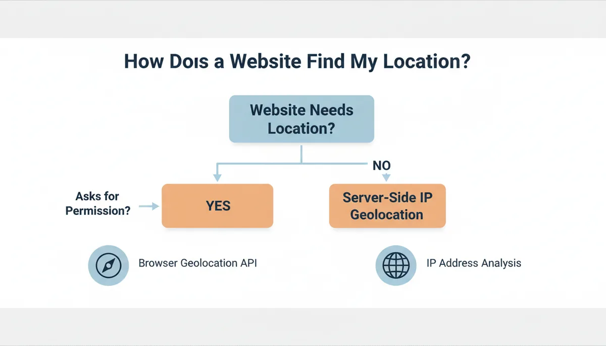
This distinction has a practical payoff. When a site shows you the wrong local weather or the wrong store hours and it never asked for location permission, it's guessing from your IP. The fix isn't repairing your IP's geolocation — it's clicking "Allow" on the permission prompt or typing your city into the site's settings. You'll get a better answer in two seconds than weeks of database corrections would deliver.
Frequently Asked Questions
If my IP location is wrong, does it affect my internet speed?
No. The registered city is a label in a database; your packets never route through it. Speed is determined by your connection's bandwidth and the latency between you and the server you're talking to. One small nuance: if your traffic genuinely exits via a distant PoP, that physical path can add a little latency — but that's the network design, not the database entry, and a hub 100 km away costs you on the order of a millisecond. You will never notice it.
Can I force my IP address to show my real city?
Not directly. The location tied to your ISP-assigned address is controlled by your provider's registration and network design, plus whatever the geolocation databases have inferred. Your options are workarounds: a VPN with a server in your actual city will make you appear to be there (a mask, not a correction), and correction requests to the database providers can help if the entire block is genuinely misplaced. But for most residential "wrong city" results, the databases are accurately reporting your PoP — there's nothing incorrect to fix.
Why does my location change when I switch from Wi-Fi to mobile data?
Because you've switched internet providers. Your home ISP and your mobile carrier are separate networks with separate address blocks, separate registration records, and separate infrastructure. Your home connection geolocates to your ISP's PoP; your phone geolocates to your carrier's gateway, which is usually more centralized and often sits behind CGNAT, where many customers share one public IP. Two providers, two pools, two different cities on the map. Both can be "right" as far as the databases are concerned.
My IP shows I'm in another country, but I'm not using a VPN. What's wrong?
Work through the likely causes in order. First, check whether you're on a corporate or university network that routes traffic through another country — this is the most common innocent explanation. Second, check for a forgotten browser extension; many "VPN" or "privacy" extensions proxy your traffic without much fanfare. Third, cross-check on a different lookup site, because one database may simply be stale. If it's your plain home connection, persistent across sites for weeks, the likely cause is a recently transferred IPv4 block whose old registration hasn't aged out of the databases yet. If it's actively breaking services you rely on, contact your ISP — and if it's persistent and unexplained, a misconfiguration on their end is possible, just rare.
Do IPv6 addresses have more accurate geolocation than IPv4?
Not inherently. Both versions travel the exact same supply chain: registry allocation, ISP registration, database inference. If anything, IPv6 geolocation is often less refined today, because providers have spent two decades accumulating latency measurements and corrections for IPv4 space and have a shorter history with IPv6. The bigger practical difference is that IPv6 devices frequently rotate temporary privacy addresses, which makes any per-address data less stable. Same system, same accuracy ceiling.
Will getting a static IP address from my ISP give me a more accurate location?
No. Static means the address doesn't change; it says nothing about where the address is registered. Your static IP comes from the same infrastructure as the dynamic ones, so it inherits the same PoP city. There is one genuine advantage: any corrections you submit to geolocation providers will stick, because the address stays yours long enough for the databases to update. With a dynamic IP, you may be assigned a different address before your correction ever propagates.
Why do different IP lookup websites show slightly different locations for the same IP?
Because they're not measuring you — they're each querying a database, and they don't all query the same one. One site subscribes to MaxMind, another to IP2Location, another uses a free Lite-tier database refreshed monthly. Each provider weights its evidence differently and publishes on its own cycle, so their answers for the same address routinely differ by a city or a postal code. When the sites disagree, the correct reading is that the truth is fuzzy somewhere across their answers — usually at whichever network facility they all orbit.
The pattern underneath everything in this article is simple: your IP address was built to route traffic, and geolocation is a layer of educated guesswork strapped on afterward. A wrong city is that guesswork showing its seams. Now you know where the seams are — and more importantly, which two or three situations deserve more than a shrug.
Sources
- ARIN (American Registry for Internet Numbers) — Claims about how IP address blocks are requested by and assigned to organizations like ISPs in North America.
- RIPE NCC (Réseaux IP Européens Network Coordination Centre) — Claims about the IP address and ASN registration process in Europe, backing the idea that location data originates with ISP registrations.
- MaxMind — Specific claims about geolocation accuracy levels for country, state, and city, and the methods used to compile their database.
- IETF (Internet Engineering Task Force) — General claims about the technical standards and formal discussions around internet protocols, including privacy and location data challenges. Can search for RFCs on geolocation.
- FCC National Broadband Map — General context about ISP infrastructure and service areas, which underpins the discussion of why an IP's location is tied to network architecture rather than a user's home.